


Yesterday and Today
By Tim Lambrinos
There are 13 utility hydro corridors in the City of Toronto. These lands allow space for high-voltage transmission towers and occasionally for oil and gas pipelines. In total, the corridors stretch for a distance of 160 kilometres and cover an estimated 1,400 hectares.
It was the Reliable Energy and Consumer Protection Act that amended the Electricity Act and transferred lands owned by Hydro One to the Government of Ontario. Hydro One is the largest shareholder of the corridor lands having ownership of 47 percent. The Vanguard Group Inc. is the second largest shareholder that owns two percent of common stock and 1832 Asset Management L.P. holds about 1.7 percent of stock.
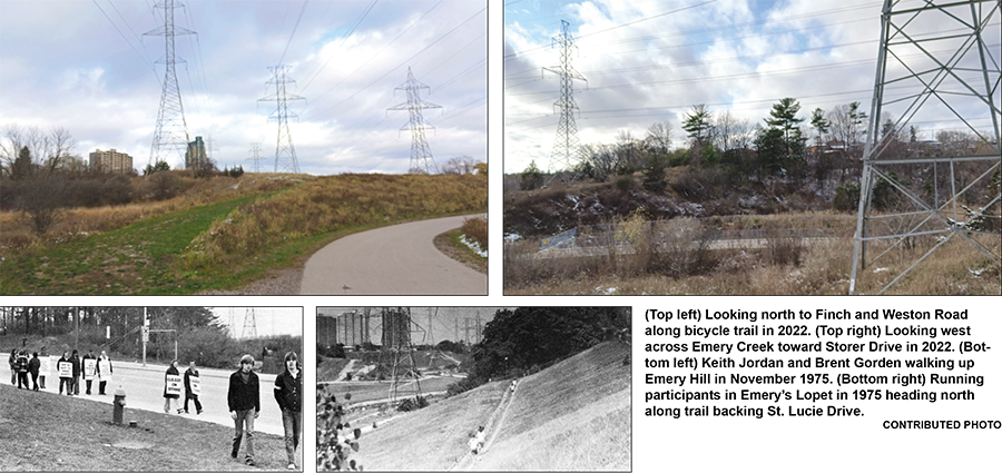
Emery’s local hydro corridor runs through sections of the Humber River and the Emery Creek ravines. The hydro towers were initially planned in 1948. By 1950, three separate hydro towers and their accompanying lines ran through Emery’s valley lands and created the utility system still in place today.
Locally, it was Richard Storer and Charlie Grubb that had their farms sub-divided by the government to allow three separate lines of hydro towers to be built. Grubb’s farmhouse was located near Franson Crescent and St. Lucie Drive and Storer’s farmhouse was near Windhill Crescent and Goldpine Crescent. The hydro lines that travel between their former farms and through the Emery Creek ravine extend from Etobicoke, near Kipling and Rexdale, and continue northeast up to Finch and Weston Road.
Emery’s hydro electric land is now called the Humber Pearson Corridor that begins south of Eglinton and travels northeast through the 401/427 interchange. All lands surrounding this corridor are mainly parkland and open spaces but have some industrial lands mixed in near Rexdale Boulevard.
The remaining adjacent lands are residential lots or ravines. Most of this corridor is grass except where the lines cross the Humber Valley in Etobicoke where a few industrial parking lots and commercial yards encroach on them.
The Humber Pearson Corridor diverts directly into the Finch Avenue Corridor near Finch and Arrow Road. This east-west corridor runs just north of, but parallel to Finch Avenue, between Highway 400 and the city’s eastern boundary. Much of the adjacent land in this corridor is zoned residential with the exception of some commercial or industrial sections mixed into intermittent pockets.
A few parking lots are located right in this corridor too, as well as the York University Busway, the G. Ross Lord Dam Reservoir, at least two cricket pitches, seven soccer fields and two community gardens. A substantial number of enhancements were done in these hydro fields approximately 10 to 15 years ago.
All of today’s pathway enhancements began with the submission of a city staff report in 2012. What occurred was the City of Toronto transportation staff consulted with the Toronto and Region Conservation Authority, Toronto Parks, Forestry and Recreation, Hydro One, Toronto Water and a number of other stakeholders in an effort to ultimately enhance Toronto’s bikeway system and trail connections.
A feasibility assessment was conducted that included reviewing design considerations and providing preliminary estimated costs. As a result, 77 km of new bicycle paths were recommended to be built on the existing network of 286 km of bikeway trails. Twelve new trail construction projects, totalling approximately 30 km, and four trail feasibility studies were undertaken as short term priorities. These were to be implemented in one to five years. City staff also evaluated all of the existing major multi-use trails to identify gaps and links that were needed to be upgraded. The Bikeway Trails Implementation Plan also included an annual program that would upgrade the existing trails where safety and connectivity was of prime concern. In addition, the plan called for the development of new trail design guidelines and a signage program that would inform trail users on how to navigate through the system.
Transportation staff also worked with Parks, Forest and Recreation staff to develop consistent maintenance practices for all major multi-use trails that were part of the new bikeway network. This was done to ensure consistent quality of service throughout the entire system.
The estimated annual cost to construct new trails and upgrade existing trails had been estimated to cost $6.0 million which was included in the Transportation Services Approved 10-Year Capital Plan for the years 2012-2016. An Inter-Agency Bikeway Trails Planning and Implementation Working Group was assembled to coordinate capital budget priorities to ensure coordination across the relevant divisions in setting capital budget priorities, establish timing, obtain approvals and develop common approaches to maintenance and other trail-related activities. All of these improvements along the trails have now become a reality along most of them.
In years’ past, Emery’s local hydro corridor had occasionally been used for cross country races and other events for students at Emery Collegiate. In 1975, Gord Sylvester won the annual Lopet Race (cross country race) through the hydro corridor and Emery Creek ravine. That race, of course, was held on dirt pathways as the trails had not yet been paved with asphalt, as they are today.
These days the corridor’s bicycle trail system has been enhanced to a level worthy of great public appreciation. The whole trail system connects to and provides bicycle and walking paths (with bridges) that travels all the way downtown.
As society continues to evolve, the history of the nearby ravine and the rural nature of the Emery Creek and Humber River haven’t changed all that much in personality, over the past two hundred years.
Even with all the enhancements and improvements that continue to change the local landscape, some things always seem to stay the same.