


 Watershed Tree Caching - A New Interactive Tool
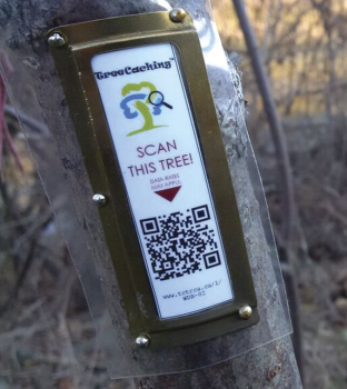
Best described as part scavenger hunt and part self guided nature walk, TreeCaching™ is popping up across our watersheds, providing new opportunities for trail users to plug into their surroundings in a 21st century kind of way. Developed by ACER (Association for Canadian Educational Resources), one of Toronto and Region Conservation Authority’s (TRCA) long standing community partners, TreeCaching™ is a tree tagging system which uses QR code technology to access a webpage containing information on a particular tree and/or feature along a trailway. This information includes the Latin and common name(s), diameter, the amount of carbon sequestered, GPS location, photos and descriptions of tree parts (e.g. leaves, buds, bark, flowers and fruit).
In TRCA’s Watershed TreeCaching™ experience, users can expect to find additional notes about the significant cultural and natural heritage of the site that they are visiting. Users can expect to find 15-20 tagged trees along existing trails. In 2015, TRCA will launch two self guided watershed TreeCaching™ experiences in the Humber River watershed and 2 in the Etobicoke and Mimico Creek watersheds. Just in time for the beautiful Thanksgiving weekend this fall, experiences were opened up at both Claireville and Heart Lake Conservation Areas, in Brampton. An experience in North Johnson District Park and Veterans Park in Woodbridge has just opened this month in partnership with the Rotary Club of Woodbridge. 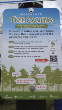
So, if you’ve ever taken a stroll through a forest and wondered ‘What type of tree is that?’, ‘Is this a Black Maple or a Sugar Maple?’ or ‘What was here before this trail?’ then a Watershed TreeCaching™ experience is for you. It’s as simple as downloading a QR code reader onto your smart phone or tablet, locating a Watershed TreeCaching Experience near you and making your way to the the trail. To find a Watershed TreeCaching™ experience near you please visit www.tctrca.ca