


Our new trail system on an age-old floodplain
By Tim Lambrinos
Around 60 years ago, the property where Daystrom Drive Public School and Lanyard Park stand today was still part of an amply sized farm. During the 1940’s and 1950’s, Richard Storer was the farmer who cultivated its crops, had cattle and ran a printing business on site.
Storer’s parcel of land terminated at an embankment to the west that bordered the Humber River. Since there is an intense bend in the river, the low lying connecting field had always been classified as a floodplain. Every seven years or so, the banks of the Humber River would swell over this spot and the plain would become an unrefined lake. At some point in the 1960’s, the Toronto Regional Conservation Authority (TRCA) placed enormous white boulders along the bend to assist securing the bank and restrain flooding.
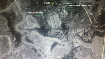
In 1960, new homes were built on top of the hill right over Storer’s former apple orchard. These streets included Storer Drive, Goldpine Crescent and an extension of Windhill Crescent. Although Daystrom Drive Public School was built a year prior, at the time only a few select homes had been fully completed in the entire area. In 1958, new homes were built for several select streets including Ironwood, Windhill and Stanwood. During these initial first two years of home building, area children were required to attend the old Emery Public School that was located at Finch and Weston Road.
The ravine itself once involved a legendary, prehistoric trail used by the Huron Indians. The trail was called the Toronto Carrying Place and would trek through the Emery creek at a point nearby. It was a significant trail that traveled on the east side of the Humber River, beginning at Lake Ontario. The winding sections of Weston Road, south of Sheppard, were once part of this great trail. The local tribes found the roadway more practical to use and gain access to Georgian Bay and the upper Great Lakes.
A segment of Islington Avenue, north of Italian Gardens, was also part of that incredible trail.
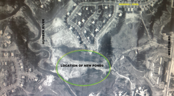
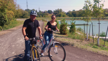
In 1997, the City of Toronto’s Works Department identified a need to clean up storm water traveling into the Emery creek. The pollution was the result of needless industrial runoff. The pond system currently being built will filter out impurities and keep them out of the Humber River. The retention ponds are now nearing completion and construction should be finished by the spring of 2018. One extremely positive component in the project is that prominent walking and cycling trails are now part of a broader plan, creating a new layout in the ravine.
Last week, Councillor Giorgio Mammoliti took a test run on his bicycle on the newly built trails. Mammoliti has traditionally been supportive in the creation of walking and cycling trails in ravines, hydro corridors and alongside creek-beds. 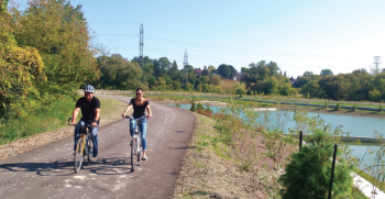
After his review, Mammoliti stated there may be a need to further enhance a newly designed lookout point immediately north of St. Lucie Drive. He also said he expects to examine this enhancement opportunity with the TRCA. One proposal is that the Emery BIA would work together with the conservation authority to further enhance and provide some finishing landscape touches at the point.
On September 6, Mammoliti was successful in convincing the Etobicoke-York Community Council to support and endorse a First Nations Park for our community. The Emery BIA is expected to spearhead the initiative. This new park is designed to pay tribute to native indigenous Canadians from our nation’s past.
The park is expected to be designed within the hydro corridor northeast of Lanyard Road on the east side of Weston Road.
If the new lookout point and trails could somehow be consistent with the First Nations theme and commemorate the Toronto Carrying Place, this could make the new trail system much more magnificent and exclusive for the community. The trails are ultimately expected to link all the way up to Finch and Weston Road.
Stay tuned. Councillor Mammoliti stated that he plans to make an official announcement and conduct a ribbon-cutting ceremony when the trail system is officially opened.