


 By Sean Delaney
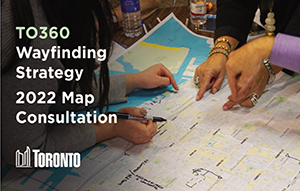
Interested in making wayfinding better in Finch West? Join #TO360 local map consultation, where your feedback will help inform Toronto’s pedestrian wayfinding maps. You can participate online or join at a pop-up. Learn more and participate at:
to360survey.com.Welcome to the TO360 Finch West local map consultation.
The website is the place to learn more about and get involved in the consultation process for the local mapping in Finch West.
The City will be hosting two rounds of consultation for local mapping for Finch West as part of TO360 from July to October 2022.
This consultation focuses on connecting with area organizations and local people with knowledge and/or interest in wayfinding in the Finch West consultation area.
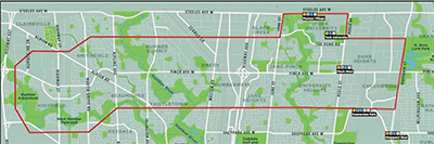
The purpose of this consultation is to seek feedback on draft wayfinding maps for the Finch West consultation area, roughly bounded by Sheppard Avenue West, Dufferin Street, Steeles Avenue West, and Highway 427.
TO360 Finch West Consultation Area.
The City is currently in Round One of consultation and the TO360 team is seeking feedback on the draft wayfinding map for the Finch West corridor. In this round, the team is specifically seeking feedback on:
• The overall accuracy of the draft map
• Places of interest and destinations that should be highlighted on the map
• Mini-District names and locations
Feedback from Round One will inform the development of refined draft wayfinding map content.
The refined draft maps will be available for review and comment in Round Two of consultation in fall 2022.
Wayfinding maps for the Finch West corridor are being prepared in anticipation of the completion of the Finch West LRT. They are not intended to show the existing ongoing construction activity along the corridor. The maps for the area will appear in future transit stations and stops and on other on-street map signage once the Finch West LRT is operational.
Since 2017, over 120 stakeholders have participated in previous local map consultations covering most of the downtown core (from High Park to The Beaches), Midtown, North York (along Yonge St.), Scarborough City Centre, western Toronto and Etobicoke Centre.
Feedback summaries from consultations in these areas are available under the “Reports & Guidelines” section of the Official City of Toronto Wayfinding page at:
www.toronto.ca/services-payments/streets-parking-transportation/walking-in-toronto/wayfinding/
Or visit the City of Toronto website at:
www.toronto.caAnd type “search” in the search box.