


By Sean Delaney
I am excited to announce that commencing next month we will dedicate a monthly feature article to be written by the TRCA (Toronto Region Conservation Authority).
While we will try to deal primarily with the areas surrounding this important Emery nature area the Humber River starts hundreds of miles away from us and is always affected by the entire length of the ecosystem.
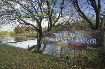
As a background, the Humber River, located in southern Ontario between Georgian Bay and Lake Ontario, flows through the Greater Toronto Area, the most urbanized centre in Canada.
From its sources in the Town of Caledon and the Townships of Adjala-Tosorontio and Mono, to its mouth at Lake Ontario in the cities of Toronto and Etobicoke, the main branch of the Humber travels 100km through a variety of natural habitats in both rural and urban landscapes. The Humber watershed has provided a home for many in the past 12,000 years, first for Aboriginal people and later for European explorers and settlers. Today, approximately 500,000 people of many different cultures live in the Humber watershed and many more travel to the watershed for work and recreational purposes. Due to its outstanding human heritage and recreational values and the contribution it has made to the development of Canada, the Humber River was officially designated a Canadian Heritage River at a plaque unveiling ceremony in Toronto on September 24, 1999.
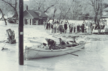
The Humber River watershed has undergone many changes, especially in the past 100 years. When environmental problems became increasingly prevalent in the 1940s, due mainly to the extensive deforestation of the Humber watershed, the Humber Valley Conservation Authority was established. On October 14 and 15, 1954 Hurricane Hazel struck the Toronto area, centred over the Humber watershed, and caused the worst documented flooding the region had ever experienced. This tropical storm caused devastating loss of life and property damage and resulted in the establishment of Canada’s first flood warning system, the beginning of flood plain regulation and management in Canada, and the formation of the Metropolitan Toronto and Region Conservation Authority (now known as the Toronto and Region Conservation Authority (TRCA) in 1957.
As part of its watershed planning responsibilities, the TRCA formed the Humber Watershed Task Force in 1994. This Task Force developed Legacy: A Strategy For A Healthy Humber to guide the management of the Humber River. In 1997, the Humber Watershed Alliance was established with a mandate to implement, at a community level, the recommendations contained in Legacy. The Alliance facilitates large watershed projects that will protect, regenerate and celebrate the Humber watershed, educate watershed residents, obtain financial resources, and prioritize spending. The Alliance is a multi-stakeholder organization whose members include representatives from watershed residents, interest groups, business associations, agency staff, and elected representatives.