


By Tim Lambrinos
The north-south expressway that geographically bounds Emery on the east is known as Highway 400. The plan to build a modern highway that would travel up to Ontario’s cottage country was devised by the province in the early 1930’s.
Prior to the highway being built, all traffic heading north to Barrie was forced to either use Highway 11 (Yonge Street) or Highway 27 (Essa Road). Weekend summer traffic congestion was a significant problem on both of these two-lane highways since both passed through many small towns on the way to Barrie.
Although not specifically identified, it is believed that there may have been military considerations with a northbound highway out of Toronto. Many large highway projects were taking place during WWII for these specific reasons. The Alaska Highway was built during the war and travelled all the way through British Columbia. It was built by the U.S. Army Corps of Engineers for protection against a possible invasion from the north. 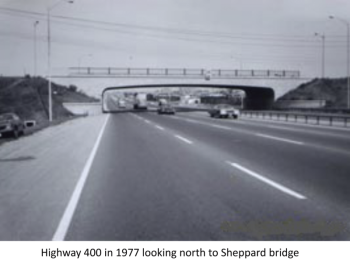
All the necessary details for a Toronto to Barrie motorway were framed-up during the war. For the new highway to be in a straight line, many lots of private farmland had to be severed. Most of these lots were 100 or 200 acre farms that ran horizontally between Weston Road and Jane Street. The highway would have to split many farms, often right in the middle of their prime farmland.
In most cases, the province undertook a balancing act when creating compensation agreements. To lessen the impact, percentages of farmers’ land were often distributed to an adjoining neighbour. As one might imagine, not all severance deals proved entirely equitable to all parties. Locally, one of the descendants of the Rowntree family had their farm severed at Steeles Avenue.
It wasn’t until 1946 that the province actually began construction on the highway. The project would take six years to complete the 74 km route (46 miles) to Barrie. Due to post-war shortages of structural steel, many bridges over the highway remained unfinished for several years after the highway’s opening. Nonetheless, most bridges were made to prominently feature the Ontario coat-of-arms embossed on both sides of the bridge’s fascia. 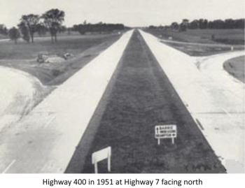
In September 1951, the northbound lanes of the highway finally opened as a single way gravel-surfaced roadway. This half of the highway was used by vehicles for three months while the southbound lanes were being paved.
Once the southbound paving was finished, their lanes were open to the public on Dec. 1, 1951. Two-way traffic ran on the southbound paved lanes over the next six months. At this time, the northbound gravel lanes were closed, re-gravelled and paved. All four lanes of the fully divided Toronto-Barrie Highway officially opened in both directions on June 30, 1952. The lanes of the new divided highway were separated by a lavish grass median. The official opening of the new highway coincided with the very busy Canada Day weekend.
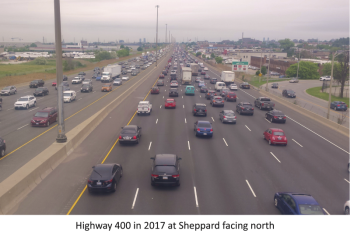
Shortly after the new dual highway opened, the Toronto-Barrie Highway was designated as Highway 400 between Toronto and Crown Hill by the Department of Highways of Ontario (DHO). Highway 400 became the first of Ontario’s superhighways to receive the prestigious “400-series” designation. At the time, the 400-series designation meant that the road was a four-lane divided highway. Of course, many of Ontario’s 400-series highways have since been widened and now have more than four lanes of traffic. Emery’s nearby overpass bridge at Sheppard (built in 1955) was initially designed with only two lanes. The bridge was modernized in 1993 to accommodate six lanes of traffic. In some sections of the 400, there is now up to six lanes of traffic travelling in any single direction.
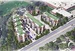
Highway 400 provides a speedy northerly route for vacationers since it bypasses all of the small towns between Toronto and Barrie. However, the route has steadily increased in importance and has now become one of Ontario’s most essential transportation corridors. The road carries thousands of commuters everyday with a considerable volume of trucks travelling to and from Ontario’s resource-rich north. Not to mention, the road has provided the means for industrial and residential intensification in many municipalities over the last decades. 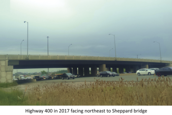
Here locally, the Emery BIA has currently retained a consultant (Sutherland and Associates) in an effort to address pending transportation needs resulting from the upcoming Finch LRT and any impacts there may be with the 400. One important point identified by Cole Engineering is that Steeles Avenue requires a full highway interchange to accommodate Emery’s trucking routes. Currently, all truck transport cannot travel from Emery BIA’s industrial core and gain northbound access to the 400, at Steeles. In these cases, all traffic is forced to use the Finch interchange only. As well, any southbound traffic coming from the north cannot exit at Steeles either. This means that all vehicles wanting to head north on the 400, or come from the north, have no choice but to overwhelm Finch.
This unforeseen jolt to Emery’s shipping and freight movement will become more of a problem once the Finch LRT is built. Essentially this means that we need the province to immediately alter our connection at Steeles to become a full-access interchange at the 400. This issue has lingered and it is now about time.